Research
Graduate Research
Ongoing | Machine Learning for Groundwater Contaminant Transport
My current research focuses on improving the modeling and prediction of groundwater contamination at legacy waste sites. I am especially interested in how physics-based groundwater models and machine-learning surrogate models can be combined to better understand contaminant migration, uncertainty, and long-term risk.
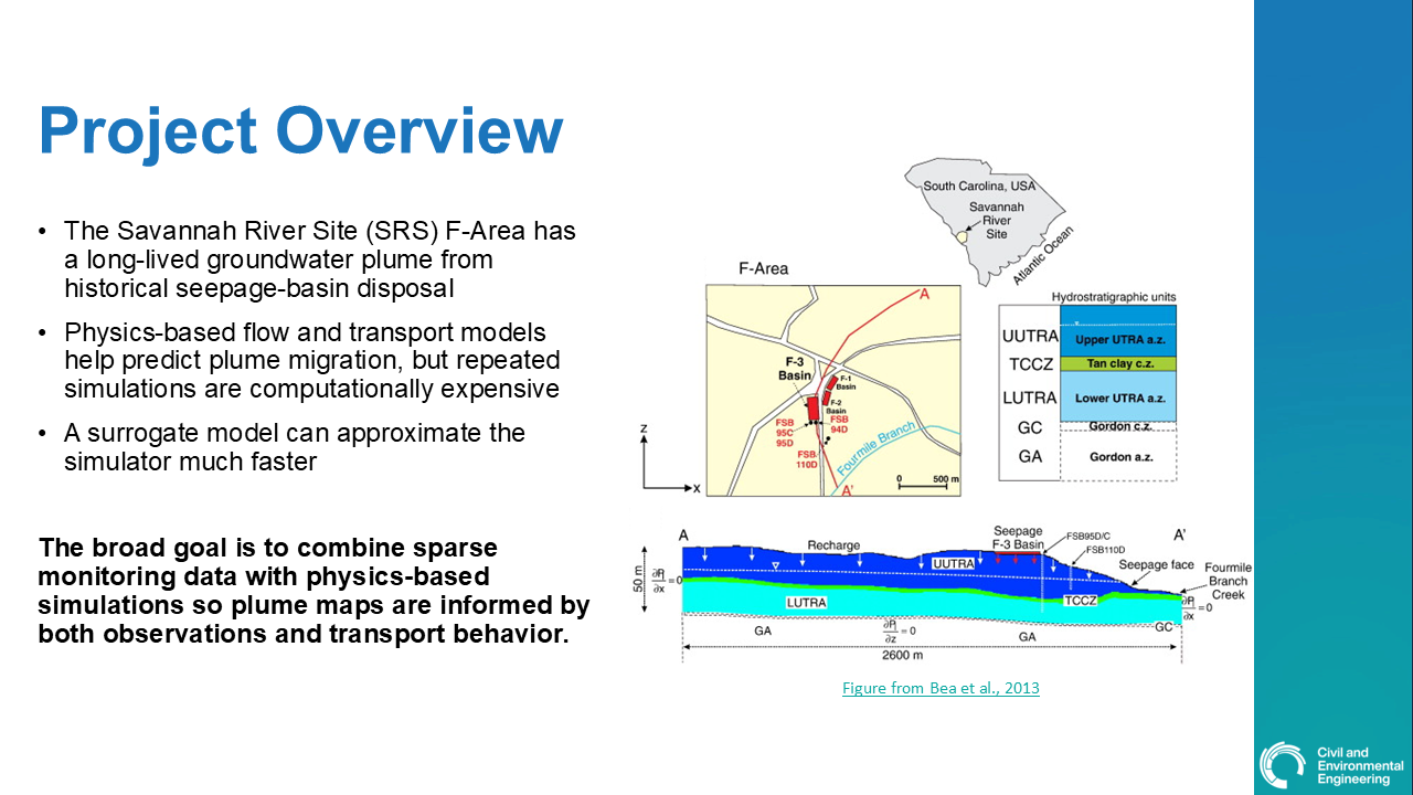
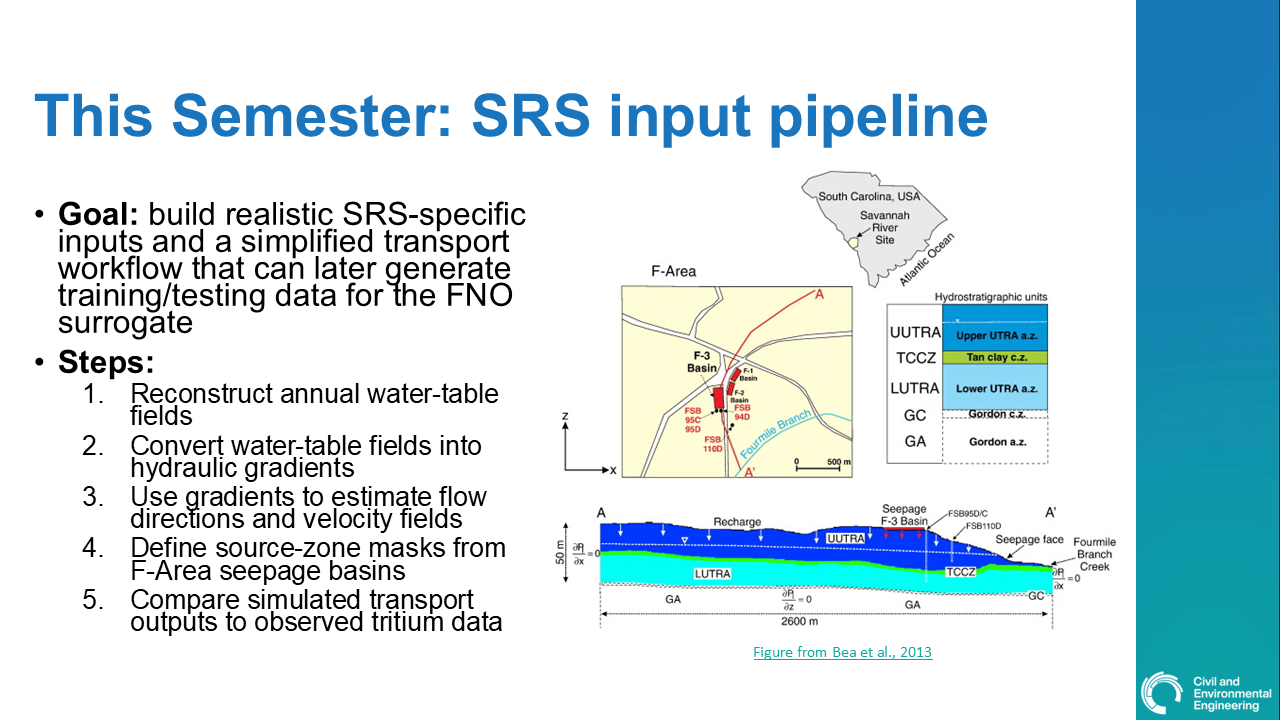
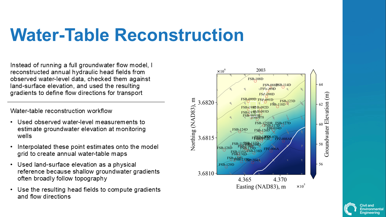
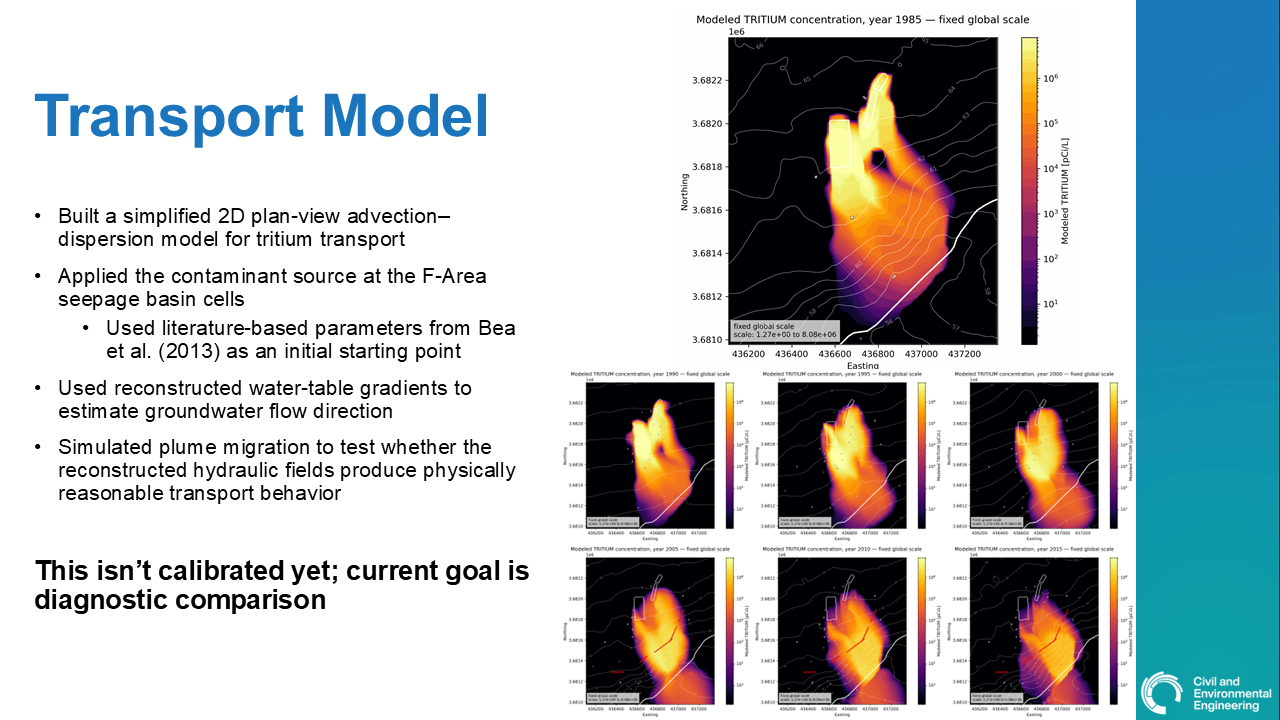
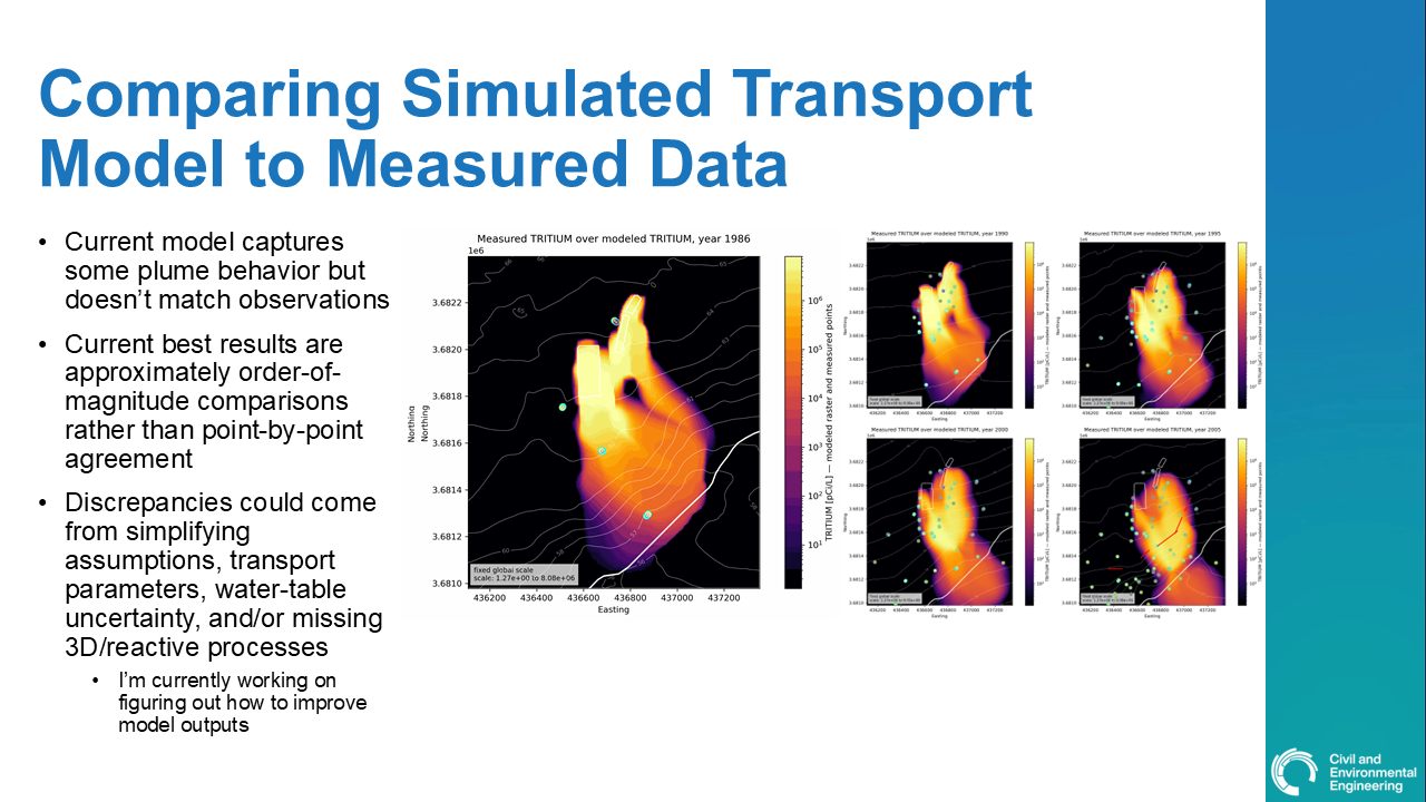
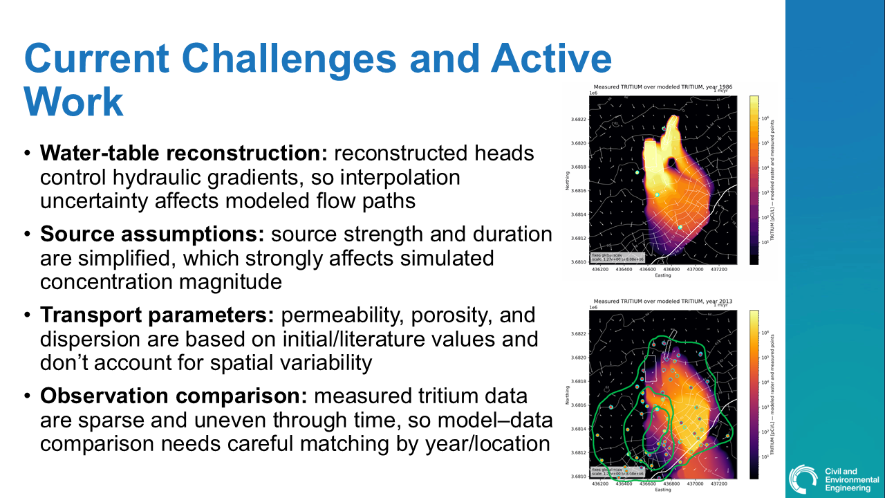
As part of my graduate research at MIT, I am studying contaminant transport at the Savannah River Site F-Area, a former nuclear materials production area in South Carolina where historical waste disposal created long-lived groundwater plumes. My work focuses on reconstructing groundwater flow conditions from monitoring data, using those flow fields to simulate contaminant transport, and comparing simulated plume behavior with observed tritium measurements.
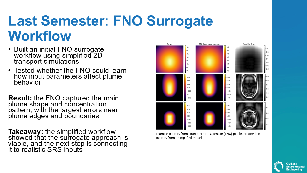
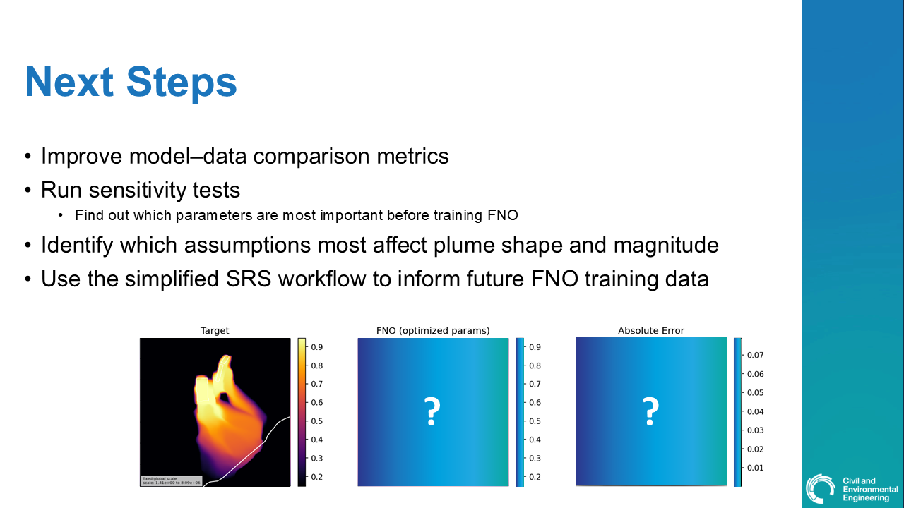
The broader goal of this research is to develop a workflow that connects sparse field observations, simplified physics-based transport modeling, and deep learning. Traditional groundwater flow and transport models are powerful, but they can be computationally expensive to run repeatedly for calibration, sensitivity analysis, or uncertainty quantification. Machine-learning surrogate models, such as Fourier Neural Operators, offer a potential way to approximate model behavior more efficiently while still retaining connections to the governing physics.
This research is still ongoing, but the current workflow includes reconstructing annual water-table surfaces, estimating hydraulic gradients and flow directions, defining source-zone regions from historical seepage basins, running simplified 2D transport simulations, and comparing modeled concentration patterns to field observations. Ultimately, I hope this work can help support the development of faster, more interpretable tools for evaluating contaminant migration in groundwater systems.
Below you can see my most recent project update.

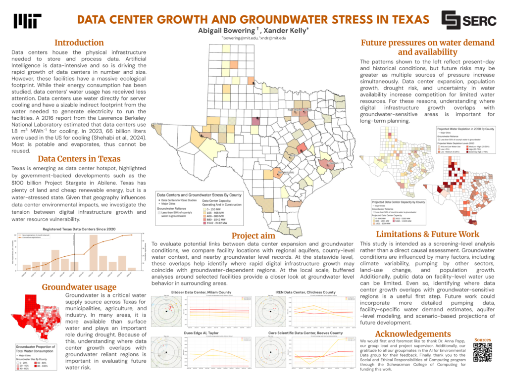
2026 | Data Center Growth and Groundwater Stress in Texas
This project investigates how rapid data center expansion may overlap with groundwater stress across Texas. Data centers provide the physical infrastructure for storing and processing digital information, and their growth has accelerated amid rising demand from artificial intelligence and cloud computing. While data centers are often discussed in terms of electricity use, their water demand is also important, as many facilities rely on water for cooling and indirectly require it through electricity generation.
Texas is an important case study because it is becoming a major data center hub while also facing long-term water stress. The state offers extensive land, energy availability, and policy support for digital infrastructure development, but many regions also depend heavily on groundwater for municipal, agricultural, and industrial uses. Because groundwater is especially important during drought, new water-intensive development could place additional pressure on already vulnerable areas.
In this screening-level analysis, we compared data center locations and planned capacity with county-level groundwater reliance, regional aquifers, projected water depletion, and nearby groundwater level records. The goal was not to prove that data centers are directly causing groundwater decline, but rather to identify where digital infrastructure growth may coincide with groundwater-sensitive regions. These spatial overlaps can help highlight areas where future water demand, drought risk, and population growth may compound existing groundwater challenges.
This work was completed with Abigail Bowering as part of MIT’s Social and Ethical Responsibilities of Computing program. The project emphasizes the need to consider water resources, not just energy use, when evaluating the environmental footprint of data centers. Future work could incorporate facility-specific water demand estimates, more detailed pumping data, aquifer-scale modeling, and scenario-based projections of future data center development.
Undergraduate Research
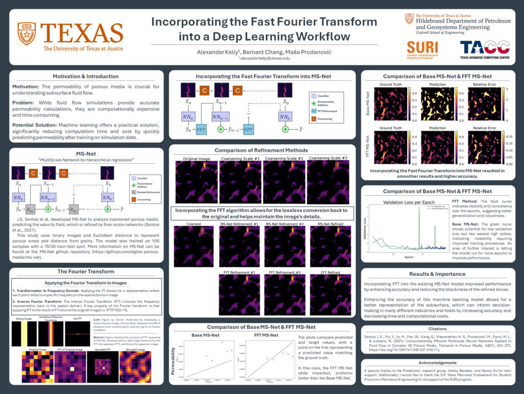
2024 | Incorporating the Fast Fourier Transform into a Deep Learning Workflow
This project focused on improving an existing machine-learning workflow for estimating the permeability of 3D porous rock samples. Supervised by Dr. Maša Prodanović and Dr. Bernard Chang, the work built on MS-Net, a deep-learning model designed to predict permeability from digital images of porous media. While physics-based flow simulations can provide accurate permeability estimates, they are often computationally expensive, making machine-learning approaches valuable for faster subsurface characterization.
My research explored whether incorporating the Fast Fourier Transform (FFT) into the MS-Net workflow could improve model performance. The FFT was used to help preserve and reconstruct image features during the coarsening and refinement process, allowing the model to better retain important pore-scale structure. By improving the quality of the reconstructed digital image slices, the FFT-enhanced workflow reduced prediction error and improved permeability estimates compared with the base MS-Net model.
This project was exciting because it connected image processing, deep learning, and subsurface flow modeling in a practical way. More accurate and efficient permeability prediction can support better characterization of subsurface materials while reducing the time and computational cost required for traditional simulations. I presented this work in the poster “Incorporating the Fast Fourier Transform into a Deep Learning Workflow.”
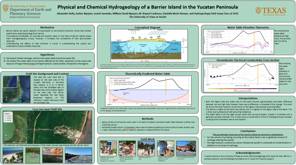
2023 | Physical and Chemical Hydrogeology of a Barrier Island in the Yucatan Peninsula
This project investigated the groundwater system of a small barrier island off the coast of the Yucatán Peninsula in Mexico. Supervised by Dr. Bayani Cardenas and Dr. Daniella Rempe, the study focused on understanding how freshwater, saltwater, brackish lagoon water, and tidal forcing interact within a narrow island aquifer.
Barrier islands are hydrologically vulnerable because their freshwater resources are limited and easily affected by surrounding saline and brackish waters. Through field measurements of water levels and electrical conductivity, we characterized the island’s groundwater gradients, tidal influence, and salinity structure. The results showed that the island’s groundwater system is highly sensitive to tidal forcing and especially vulnerable to overpumping, which could draw saline or brackish water into the shallow aquifer.
This project was especially meaningful because it connected hydrogeologic theory directly to a real coastal community where groundwater availability affects daily life. I presented this work at the 2023 American Geophysical Union Fall Meeting in San Francisco as a poster titled “Physical and Chemical Hydrogeology of a Barrier Island in the Yucatán Peninsula.”